The weekly litigation news digest is live. Subscribe now
Slope Stability Lidar - EP3362816
The patent EP3362816 was granted to Groundprobe on Jan 22, 2025. The application was filed on Oct 12, 2016 under application number EP16854637A. The patent is currently recorded with a legal status of "Patent Maintained As Amended".
EP3362816
- Application Number
- EP16854637A
- Filing Date
- Oct 12, 2016
- Status
- Patent Maintained As Amended
- Dec 20, 2024
- Publication Date
- Jan 22, 2025
- External Links
- Slate, Register, Google Patents
Patent Summary
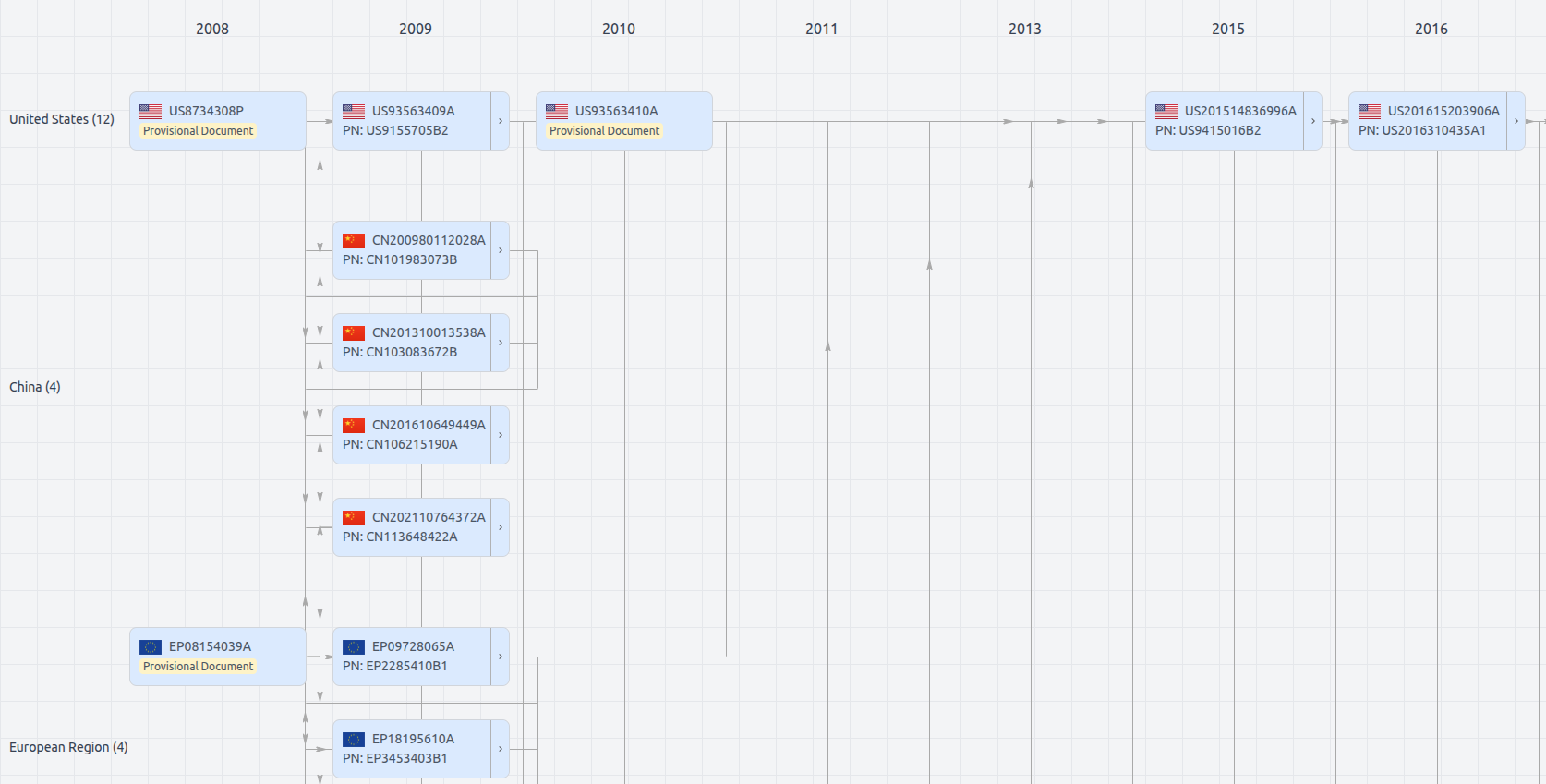
Patent Family
Patent Oppositions (2)
Patent oppositions filed by competitors challenge the validity of a granted patent. These oppositions are typically based on claims of prior art, lack of novelty, or non-obviousness. They are a key part of the process for determining a patent's strength and enforceability.
| Company | Opposition Date | Representative | Opposition Status |
|---|---|---|---|
| RIEGL LASER MEASUREMENT SYSTEMS | Dec 7, 2022 | WEISER VOITH GUGLER | ADMISSIBLE |
| RIEGL LASER MEASUREMENT SYSTEMS | Dec 7, 2022 | WEISER & VOITH PATENTANWALTE PARTNERSCHAFT | ADMISSIBLE |
Patent Citations (12) New
Patent citations refer to prior patents cited during different phases such as opposition or international search.
| Citation Phase | Publication Number |
|---|---|
| INTERNATIONAL-SEARCH-REPORT | KR101009657B |
| INTERNATIONAL-SEARCH-REPORT | US2014267250 |
| INTERNATIONAL-SEARCH-REPORT | WO2012100288 |
| INTERNATIONAL-SEARCH-REPORT | WO2014201075 |
| OPPOSITION | GB2403861 |
| OPPOSITION | US2007211077 |
| OPPOSITION | US2013051655 |
| OPPOSITION | US5745422 |
| OPPOSITION | WO2007009175 |
| SEARCH | US2009121921 |
| SEARCH | US2014368807 |
| SEARCH | WO2012100288 |
Dossier Documents
The dossier documents provide a comprehensive record of the patent's prosecution history - including filings, correspondence, and decisions made by patent offices - and are crucial for understanding the patent's legal journey and any challenges it may have faced during examination.
Date
Description
Get instant alerts for new documents
Jan 7, 2025
Jan 7, 2025
Dec 18, 2024
Dec 18, 2024
Dec 18, 2024
Dec 18, 2024
Dec 18, 2024
Oct 18, 2024
Oct 18, 2024
Oct 18, 2024
Oct 9, 2024
Jun 28, 2024
Jun 28, 2024
Jun 28, 2024
Jun 28, 2024
Jun 28, 2024
Jun 28, 2024
Jun 28, 2024
Jun 28, 2024
Jun 28, 2024
Jun 28, 2024
Means of redress
OPPO
Jun 28, 2024
Jun 28, 2024
Jun 28, 2024
Jun 28, 2024
Jun 28, 2024
Jun 28, 2024
Apr 25, 2024
Mar 21, 2024
Mar 15, 2024
Mar 15, 2024
Mar 15, 2024
Mar 1, 2024
Feb 28, 2024
Feb 23, 2024
Feb 23, 2024
Feb 23, 2024
Feb 23, 2024
Feb 23, 2024
Feb 23, 2024
Feb 23, 2024
Feb 23, 2024
Feb 23, 2024
Feb 23, 2024
Feb 23, 2024
Feb 23, 2024
Feb 23, 2024
Feb 22, 2024
Feb 22, 2024
Feb 22, 2024
Feb 22, 2024
Feb 22, 2024
Feb 22, 2024
Feb 22, 2024
Feb 22, 2024
Feb 22, 2024
Feb 22, 2024
Feb 22, 2024
Feb 22, 2024
Feb 22, 2024
Feb 22, 2024
Feb 22, 2024
Feb 22, 2024
Feb 22, 2024
Feb 22, 2024
Feb 22, 2024
Feb 22, 2024
Feb 22, 2024
Feb 22, 2024
Feb 22, 2024
Feb 22, 2024
Feb 22, 2024
Feb 22, 2024
Feb 22, 2024
Feb 22, 2024
Feb 22, 2024
Feb 22, 2024
Feb 22, 2024
Oct 3, 2023
Oct 2, 2023
Sep 29, 2023
Sep 29, 2023
Sep 29, 2023
Sep 29, 2023
Sep 29, 2023
Sep 29, 2023
Sep 29, 2023
Aug 28, 2023
Aug 17, 2023
Aug 11, 2023
Aug 11, 2023
Aug 11, 2023
Aug 11, 2023
Aug 11, 2023
Aug 11, 2023
Aug 11, 2023
Aug 11, 2023
Aug 11, 2023
Aug 11, 2023
Jun 6, 2023
Jun 2, 2023
Jun 2, 2023
May 31, 2023
May 31, 2023
May 31, 2023
May 31, 2023
May 31, 2023
May 31, 2023
May 31, 2023
May 31, 2023
May 31, 2023
May 31, 2023
May 31, 2023
May 31, 2023
May 31, 2023
May 31, 2023
May 31, 2023
May 31, 2023
May 31, 2023
May 31, 2023
May 31, 2023
May 31, 2023
May 31, 2023
May 31, 2023
May 31, 2023
May 31, 2023
May 31, 2023
May 26, 2023
May 26, 2023
May 26, 2023
Jan 24, 2023
Jan 24, 2023
Dec 13, 2022
Dec 7, 2022
Dec 7, 2022
Dec 7, 2022
Dec 7, 2022
Dec 7, 2022
Dec 7, 2022
Dec 7, 2022
Dec 7, 2022
Dec 7, 2022
Dec 7, 2022
Dec 7, 2022
Dec 7, 2022
Dec 7, 2022
Dec 7, 2022
Dec 7, 2022
Dec 7, 2022
Dec 7, 2022
Dec 7, 2022
Dec 7, 2022
Dec 7, 2022
Dec 7, 2022
Dec 7, 2022
Apr 21, 2022
Mar 11, 2022
Decision to grant a European patent
Search/Exam
Feb 23, 2022
(Electronic) Receipt
Search/Exam
Feb 23, 2022
Filing of the translations of the claims
Search/Exam
Feb 23, 2022
French translation of claims
Search/Exam
Feb 23, 2022
German translation of the claims
Search/Exam
Feb 23, 2022
Letter accompanying subsequently filed items
Search/Exam
Oct 27, 2021
Oct 27, 2021
Oct 27, 2021
Oct 27, 2021
Intention to grant (signatures)
Search/Exam
Oct 27, 2021
Text intended for grant (clean copy)
Search/Exam
Oct 27, 2021
Oct 1, 2021
Oct 1, 2021
Sep 23, 2021
(Electronic) Receipt
Search/Exam
Sep 23, 2021
Letter accompanying subsequently filed items
Search/Exam
Sep 23, 2021
Non-patent literature filed by a third party
Search/Exam
Sep 23, 2021
Observations by third parties
Search/Exam
Sep 20, 2021
Sep 13, 2021
Observations by third parties
Search/Exam
Jul 9, 2021
(Electronic) Receipt
Search/Exam
Jul 9, 2021
Amended claims with annotations
Search/Exam
Jul 9, 2021
Claims
Search/Exam
Jul 9, 2021
Letter accompanying subsequently filed items
Search/Exam
Jul 9, 2021
May 25, 2021
May 25, 2021
May 25, 2021
May 25, 2021
Intention to grant (signatures)
Search/Exam
May 25, 2021
Text intended for grant (clean copy)
Search/Exam
May 25, 2021
Apr 30, 2021
Annex to the communication
Search/Exam
Apr 30, 2021
Consultation by telephone/in person
Search/Exam
Apr 30, 2021
Apr 29, 2021
Apr 23, 2021
Annex to the communication
Search/Exam
Apr 23, 2021
Consultation by telephone/in person
Search/Exam
Apr 23, 2021
Feb 19, 2021
(Electronic) Receipt
Search/Exam
Feb 19, 2021
Amended claims with annotations
Search/Exam
Feb 19, 2021
Amended claims with annotations
Search/Exam
Feb 19, 2021
Claims
Search/Exam
Feb 19, 2021
Claims
Search/Exam
Feb 19, 2021
Letter accompanying subsequently filed items
Search/Exam
Feb 19, 2021
Feb 12, 2021
Annex to the communication
Search/Exam
Feb 12, 2021
Consultation by telephone/in person
Search/Exam
Feb 12, 2021
Oct 20, 2020
Annex to the communication
Search/Exam
Oct 20, 2020
Communication from the Examining Division
Search/Exam
Sep 7, 2020
(Electronic) Receipt
Search/Exam
Sep 7, 2020
Letter accompanying subsequently filed items
Search/Exam
Sep 7, 2020
May 11, 2020
Annex to the communication
Search/Exam
May 11, 2020
Communication from the Examining Division
Search/Exam
Apr 23, 2020
Apr 16, 2020
Non-patent literature filed by a third party
Search/Exam
Apr 16, 2020
Non-patent literature filed by a third party
Search/Exam
Apr 16, 2020
Observations by third parties
Search/Exam
Apr 16, 2020
Observations by third parties
Search/Exam
Feb 28, 2020
(Electronic) Receipt
Search/Exam
Feb 28, 2020
Letter accompanying subsequently filed items
Search/Exam
Feb 28, 2020
Dec 10, 2019
Annex to the communication
Search/Exam
Dec 10, 2019
Communication from the Examining Division
Search/Exam
Dec 4, 2019
Examination started
Search/Exam
Sep 19, 2019
(Electronic) Receipt
Search/Exam
Sep 19, 2019
Letter accompanying subsequently filed items
Search/Exam
Sep 19, 2019
Priority search results
Search/Exam
Sep 19, 2019
Sep 12, 2019
Sep 5, 2019
(Electronic) Receipt
Search/Exam
Sep 5, 2019
Sep 5, 2019
Amended claims with annotations
Search/Exam
Sep 5, 2019
Amendments received before examination
Search/Exam
Sep 5, 2019
Letter accompanying subsequently filed items
Search/Exam
May 13, 2019
May 13, 2019
May 3, 2019
May 3, 2019
Non-patent literature filed by a third party
Search/Exam
May 3, 2019
Observations by third parties
Search/Exam
May 3, 2019
Observations by third parties
Search/Exam
Apr 15, 2019
Apr 15, 2019
European search opinion
Search/Exam
Apr 15, 2019
Information on Search Strategy
Search/Exam
Apr 15, 2019
Supplementary European search report
Search/Exam
Apr 1, 2019
Search started
Search/Exam
Jul 25, 2018
Jun 13, 2018
Jun 11, 2018
Communication to designated inventor
Search/Exam
Jun 11, 2018
Communication to designated inventor
Search/Exam
May 9, 2018
(Electronic) Receipt
Search/Exam
May 9, 2018
May 9, 2018
Amended claims with annotations
Search/Exam
May 9, 2018
Request for entry into the European phase
Search/Exam
Apr 26, 2018
Apr 20, 2018
Apr 12, 2018
Non-patent literature filed by a third party
Search/Exam
Apr 12, 2018
Non-patent literature filed by a third party
Search/Exam
Apr 12, 2018
Non-patent literature filed by a third party
Search/Exam
Apr 12, 2018
Non-patent literature filed by a third party
Search/Exam
Apr 12, 2018
Non-patent literature filed by a third party
Search/Exam
Apr 12, 2018
Non-patent literature filed by a third party
Search/Exam
Apr 12, 2018
Non-patent literature filed by a third party
Search/Exam
Apr 12, 2018
Non-patent literature filed by a third party
Search/Exam
Apr 12, 2018
Observations by third parties
Search/Exam
Feb 23, 2018
Information on entry into European phase
Search/Exam
May 31, 2017
Notification of election of EPO
Search/Exam
May 9, 2017
Apr 20, 2017
Copy of the international search report
Search/Exam
Apr 20, 2017
Published international application - A1
Search/Exam