Mashing Mapping Content Displayed On Mobile Devices
Patent No. US11937145 (titled "Mashing Mapping Content Displayed On Mobile Devices") was filed by Nearby Systems Llc on Sep 13, 2019.
What is this patent about?
’145 is related to the field of mapping on mobile devices. Specifically, it addresses the problem of integrating location information from various applications into a single, unified map view. Traditionally, mapping applications operated in isolation, requiring users to manually re-enter addresses or locations when switching between apps, leading to a fragmented and inefficient user experience.
The underlying idea behind ’145 is to enable seamless transfer of addressable information from any application on a mobile device to a mapping application, allowing users to view this information in the context of their existing map data. This is achieved by allowing a user to select an address in one application, and then automatically displaying that location on a map within a separate mapping application, while retaining any previously displayed map content.
The claims of ’145 focus on a system where a mobile device stores multiple non-browser applications, including at least one mapping application. When a user interacts with text representing a location within one application, a mapping component transmits a query to an online mapping service. The mapping service then displays a map in a separate mapping application, showing both the selected location and the device's current location, along with a route between the two.
In practice, this system allows a user reading an email with an address to simply tap the address, which then automatically opens a mapping application like Google Maps or Waze. The map will display the address from the email, the user's current location (determined by GPS), and directions between the two. This eliminates the need to manually copy and paste the address into the mapping application.
This approach differs from prior solutions by enabling the integration of location data from disparate sources onto a single map, without losing the context of previously displayed information. Instead of opening a new, blank map for each new location, the system intelligently adds the new location to the user's existing map view, providing a more cohesive and efficient mapping experience. The system can even prompt the user to select which mapping application to use, if multiple options are available.
How does this patent fit in bigger picture?
Technical landscape at the time
In the late 2000s when ’145 was filed, mobile devices commonly relied on GPS for location data and were at a time when mapping applications were becoming increasingly popular. At that time, integrating data from multiple sources into a single mapping interface on a mobile device presented technical challenges, especially when hardware or software constraints made efficient data processing and display non-trivial.
Novelty and Inventive Step
The examiner allowed the claims because the applicant's amendments persuasively demonstrated that the prior art, whether considered individually or in combination, did not teach the claimed invention. Specifically, the examiner found that no prior art taught all the limitations of the amended claims, and there was no reasonable motivation to combine the known elements in the prior art to achieve the claimed invention. The examiner stated that the closest prior art, Kreitler, taught some elements of the claims, but lacked other limitations. Cover et al. disclosed displaying a list of applications for the user to choose from to load data/file. However, the cited art does not teach every limitation as claimed.
Claims
This patent contains 9 claims, with claims 1 and 7 being independent. The independent claims are directed to systems for displaying location-based content on a digital map displayed on a mobile device, involving communication between non-browser applications and online mapping services. The dependent claims generally elaborate on the features and functionalities described in the independent claims, such as the communication methods, map display characteristics, and query parameters.
Key Claim Terms New
Definitions of key terms used in the patent claims.
Litigation Cases New
US Latest litigation cases involving this patent.
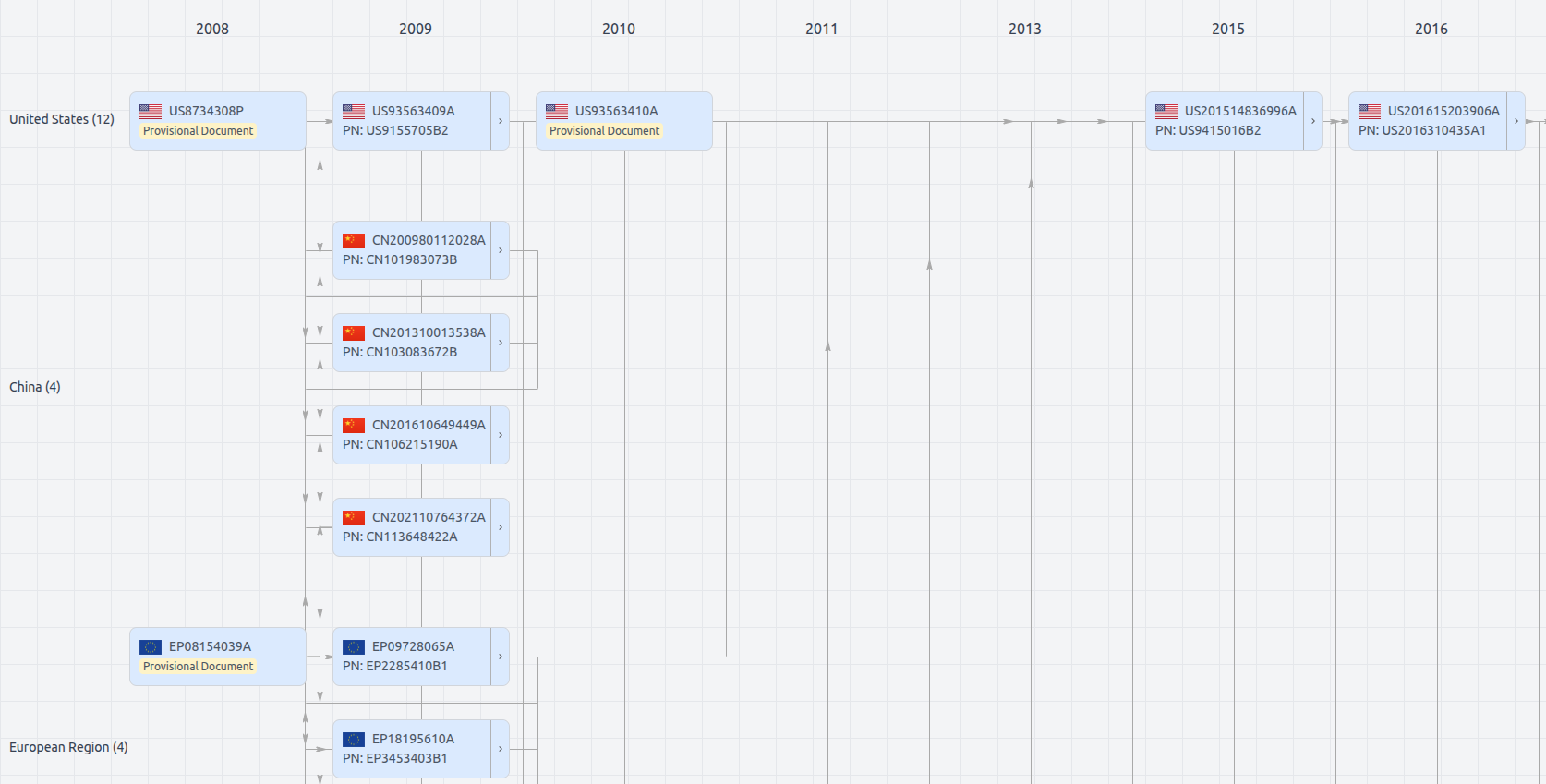
Patent Family
File Wrapper
The dossier documents provide a comprehensive record of the patent's prosecution history - including filings, correspondence, and decisions made by patent offices - and are crucial for understanding the patent's legal journey and any challenges it may have faced during examination.
Get instant alerts for new documents
US11937145
- Application Number
- US16570298
- Filing Date
- Sep 13, 2019
- Status
- Granted
- Expiry Date
- Oct 17, 2028
- External Links
- Slate, USPTO , Google Patents