Method to provide ad hoc and password protected digital and voice networks
Patent No. US9820123 (titled "Method to provide ad hoc and password protected digital and voice networks") on Sep 1, 2016. The application was issued on Nov 14, 2017.
What is this patent about?
'123 is related to the field of mobile communication systems, particularly those used in ad hoc networks for coordinating activities in emergency situations. The background involves the increasing use of cellular phones with integrated PDAs and GPS for communication, navigation, and data exchange. Existing solutions often require pre-entry of data or are cumbersome to set up quickly, especially in scenarios involving multiple organizations with different communication systems.
The underlying idea behind '123 is to enable rapid establishment of a temporary, password-protected communication network among mobile devices. This is achieved by having each device connect to a central server using a shared event name and password. The server then facilitates the exchange of location and status information between all connected devices, allowing users to see each other's positions on a georeferenced map without needing to manually enter contact details.
The claims of '123 focus on a computer-implemented method performed by a mobile device. The device receives a message to join a group, sends its location to a server, and receives location data for other group members. It then displays a georeferenced map with symbols representing the other members. The user can select a symbol on the map, specify an action, and the device will use Internet Protocol to send data to the corresponding member. The selection of the symbol is based on detecting user interaction with the display and identifying the symbol nearest to the selected position on the map.
In practice, each user enters a server IP address, an event name, and a password into their device. The device then reports its GPS location and status to the server. The server acts as a forwarder, distributing this information to all other devices logged in with the same credentials. This allows for a dynamic display of all participants on a map, enabling quick coordination. The system also supports sending targeted messages or initiating calls by selecting a participant's symbol on the map.
This approach differs from prior solutions by eliminating the need for pre-configured contact lists or manual data entry. The centralized server architecture simplifies network setup and management, especially in dynamic environments where participants may join or leave frequently. Furthermore, the use of a georeferenced map provides a visual and intuitive interface for coordinating activities, particularly useful for first responders or military personnel who need to quickly understand the spatial relationships between different units.
How does this patent fit in bigger picture?
Technical Landscape
In the mid-2000s when ’490 was filed, mobile data communication was at a time when location-based services were typically implemented using specialized, standalone GPS hardware or early-stage integrated handsets that functioned primarily as voice-centric devices. When systems commonly relied on pre-configured contact lists and manual entry of phone numbers or email addresses to establish connections, the dynamic formation of groups was limited by the lack of real-time, server-mediated coordination. Hardware and software constraints of the era made the simultaneous processing of live GPS telemetry, interactive mapping, and ad hoc network authentication non-trivial for handheld devices, which often operated on low-bandwidth cellular data links that favored static information over continuous spatial data exchange.
Prosecution Position
The examiner allowed the application because the prior art did not teach the specific combination of steps for managing an ad hoc group via an interactive map interface. While earlier systems could display member locations or handle conditional messaging, they lacked the integrated method of receiving a group-joining message, exchanging real-time location data through a server to populate a georeferenced map, and then using that map to initiate IP-based communication. Specifically, the examiner noted that the prior art failed to show a system where a user can select a symbol on a map—identified by the system as the closest icon to a touch coordinate—and automatically trigger a specific data action sent to that corresponding group member via Internet Protocol.
Claims
This patent contains 48 claims, of which claims 1, 14, 23, and 36 are independent. The independent claims are directed to a computer-implemented method and system for presenting a georeferenced map with user-selectable symbols corresponding to devices in a group and enabling user interaction with those symbols. The dependent claims generally add further detail and limitations to the independent claims, such as specifying types of data sent, additional functionalities, and specific components.
Key Claim Terms New
Definitions of key terms used in the patent claims.
Litigation Cases New
US Latest litigation cases involving this patent.
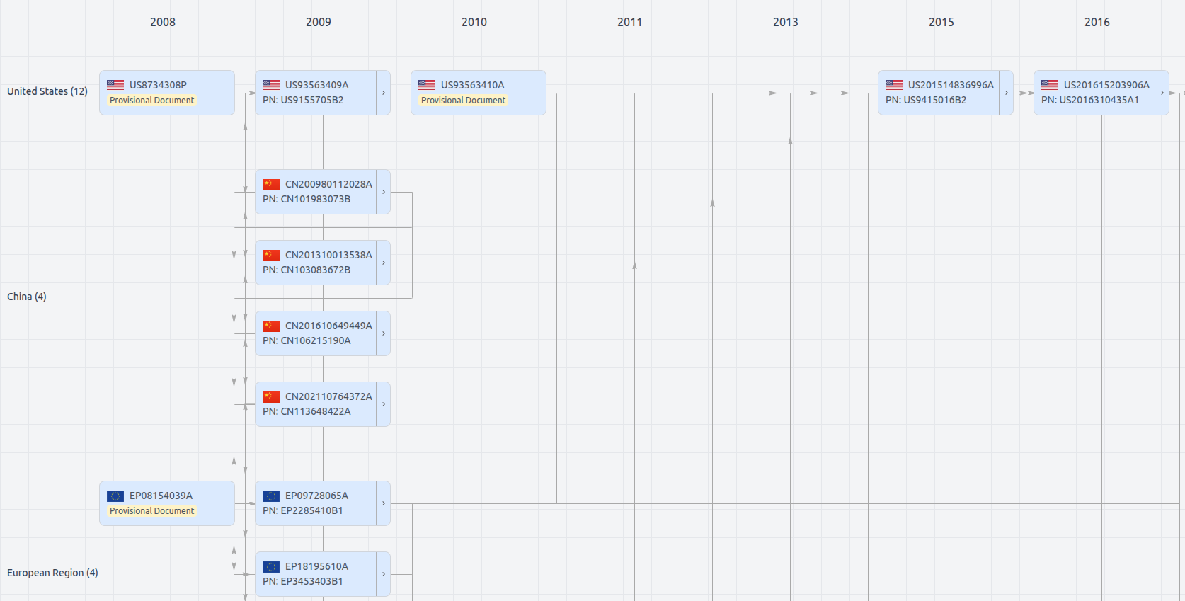
Patent Family
File Wrapper
The dossier documents provide a comprehensive record of the patent's prosecution history - including filings, correspondence, and decisions made by patent offices - and are crucial for understanding the patent's legal journey and any challenges it may have faced during examination.
Get instant alerts for new documents
US9820123
- Application Number
- US15255046A
- Filing Date
- Sep 1, 2016
- Publication Date
- Nov 14, 2017
- External Links
- Slate, USPTO , Google Patents